- Services
- All Services
- All Locations
- Surveying
- Drone Infrastructure Services
- Drone Services for Agriculture
- Drone Inspection for Cell Towers
- Drone Media Services
- Drone Mapping Services
- Drone Mining Inspection
- Drone for Surveillance And Security
- Industrial Robotics and Unmanned Systems
- Semiconductor Design and Innovation Services
- Factory Automation Solutions
- Portfolio
- Unmanned Products
- Drone Training
- Blog
- Brochure
- Contact us
Surveying & Aerial Technology Insights
The Truncated Version Of Surveying & Aerial Technology Insights, As Used Today, In Mining, Construction, And Environmental Sectors.
Surveying & Aerial Technology Insights have become essential to the mining, construction and environmental sectors in the area of accurate data collection and making informed decisions about resource allocation and business processes. As drones have evolved, firms such as Dronitech have converted the old way of doing surveys into faster, safer and more precise methods for providing aerial data.
Surveying & Aerial Technology Insights Is Basically Defined As…
Drones, sensors, and advanced software used to create high-resolution aerial data used for mapping, measuring, analyzing and monitoring; these analyses allow for superior visual understanding of the areas under investigation. This is achieved by using modern surveying techniques with extremely low overhead for companies involved with environmental issues.
The Evolution Of Drone Use In Modern Surveying
The advent of drone technology has changed how we collect and analyze data in the survey industry. Drones are used within Surveying & Aerial Technology Insights , as they provide more accurate mapping and measuring of surfaces than any other means available today. Dronitech uses Surveying & Aerial Technology Insights to offer industries reliable aerial intelligence.
Benefits Of Surveying With Drones
When utilizing drone-based surveying, companies can:
Create maps and measures with a high degree of accuracy.
Acquire data faster than traditional methods of surveying.
Increase safety for their workers due to lower on-the-ground risk.
Take advantage of cost savings and scaleability afforded by drone technology. These benefits make Surveying & Aerial Technology Insights necessary tools in today’s project planning and implementation phases.
Insights gained from Surveying and Aerial Technology have many uses.
Land Surveying and Mapping
Drones allow for accurate elevation mapping, with topographical maps as well as contour models and 3D representations. By providing accurate geospatial information, Dronitech uses Surveying/Aerial Technology Insights to create the topographical information needed to support urban development and land development as well as infrastructure projects.
Construction and Infrastructure Monitoring
Surveying and Aerial Technology Insights have improved how contractors track jobsites, calculate structure volumes, and examine construction sites. By providing real-time information offering aerial insight into the jobsite, construction managers can monitor their construction schedules; discover developing problems before they can become a serious issue and improve their ability to work together on the project..
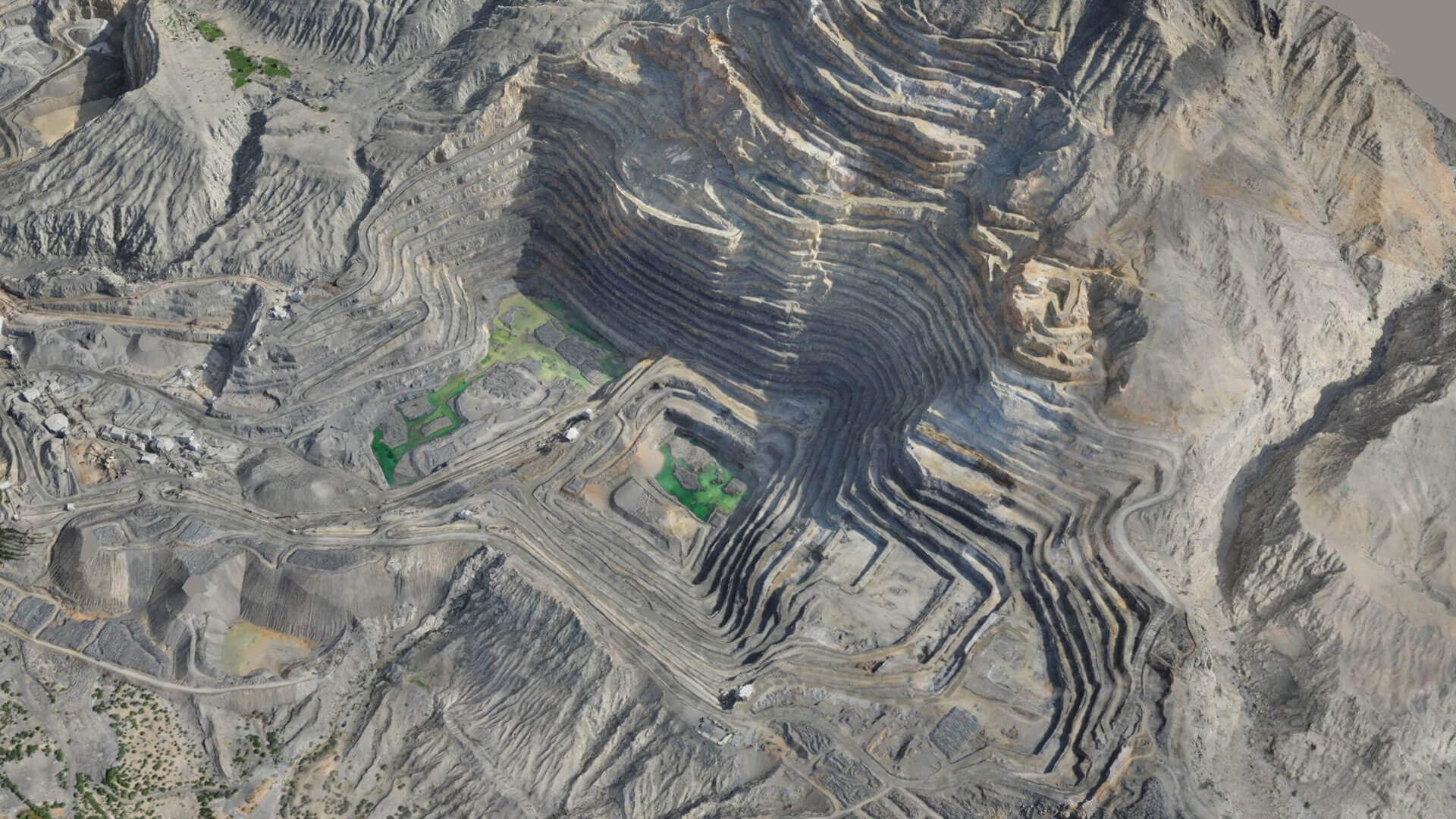
Mining and Quarry Surveying
Safety and accuracy are paramount in mining operations. Through Surveying and Aerial Technology Insights, mining companies can accurately calculate stockpile volumes, perform pit analysis, and monitor operations without compromising productivity or exposing employees to potentially hazardous working environments.
Agricultural and Environmental Analysis
Information gathered from aerial surveys is critical for both environmental assessments and Precision Agriculture. Drones, using information derived from Surveying and Aerial Technology Insights, can support environmental monitoring vegetation assessments and land use planning and managing water resources.
Why Surveying and Aerial Technology Data is Important to You Today
As Periodic Reports become increasingly complex (due to increasing amounts of knowledge being accumulated over greater lengths of period), the need for data-driven decision-making becomes necessary. Surveying and Aerial Technology Insights create the action-oriented information that ensures the accuracy of site and project data (increased accuracy reduces both input error and time) improving the overall efficiency of the organisation. When a company like Dronitech provides Surveying and Aerial Technology Insights, that enables a company to deliver and empower clients through the use of accurate, real-world data.
Dronitech uses multiple technologies; more specifically, they use drones to collect high-definition imaging and elevation data through high-definition cameras and positioning systems. They then use sophisticated software capabilities to interpret, organize, and present their collected information in accordance with best industry practices. Dronitech’s survey-aerial technology capabilities provide flexibility at every step from data collection through reporting and finalize the project to meet customer specifications and abide by regulations.
Dronitech’s Vision of Aerial Technology
Dronitech’s vision of aerial technology is that the technology will continue to expand through the increased use of automation through Artificial Intelligence and the collection of real-time data. Dronitech also believes that the future of Aerial Technology lies with integrating aerial survey data into the operating platform of businesses for increased accuracy and scalability.
Summary
Dronitech is changing how businesses collect, analyze, and utilize the spatial data through aerial surveys with drone technology. By using Dronitech’s aerial technology, businesses gain insight into their operations in a way that was previously unavailable, resulting in a better understanding of their customers and an advantage in today’s data-driven environment.