- Services
- All Services
- All Locations
- Surveying
- Drone Infrastructure Services
- Drone Services for Agriculture
- Drone Inspection for Cell Towers
- Drone Media Services
- Drone Mapping Services
- Drone Mining Inspection
- Drone for Surveillance And Security
- Industrial Robotics and Unmanned Systems
- Semiconductor Design and Innovation Services
- Factory Automation Solutions
- Portfolio
- Unmanned Products
- Drone Training
- Blog
- Brochure
- Contact us
Drone Aerial Survey in Mumbai for Construction Progress Monitoring & 3D Mapping
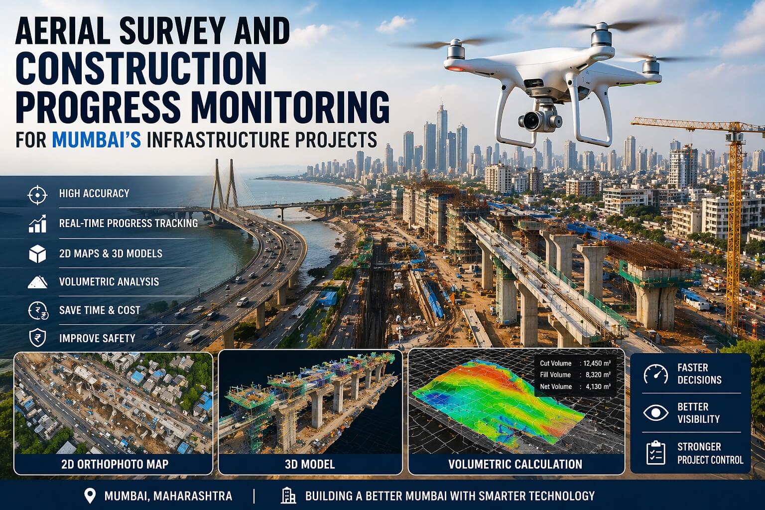
Looking for drone aerial survey in Mumbai? Get precise mapping, faster data collection and real-time project monitoring for construction sites.
Mumbai is a city that never stops building. Every day, new high rise buildings, flyovers, metro lines, and coastal roads are being constructed. But building in Mumbai is not easy. Space is small. Traffic is heavy. Deadlines are tight. And mistakes are very costly.
That is why many construction companies in Mumbai are now using aerial survey and drone progress monitoring. Instead of walking around with a total station or using old maps, they use drones to get accurate data in minutes.
Dronitech offers drone mapping and surveying services across India. We provide high resolution 2D and 3D maps, orthophotos, and volumetric measurements. For Mumbai’s infrastructure projects, this is a game changer.
Problems with Traditional Survey Methods in Mumbai
Traditional land surveying uses tools like the total station. A person stands on the ground and takes measurements one by one. This is slow. On a big site, it can take many days or even weeks.
Also, Mumbai has many obstacles. Old buildings, narrow lanes, and uneven ground make surveying hard. If the site is large, workers get tired. Human errors happen.
Another problem is traffic. Getting a survey team to move from one location to another in Mumbai can take hours. All this costs time and money.
How Drone Aerial Survey Works
Dronitech uses drones that fly over your construction site. The drone takes hundreds of photos from different angles. Special software then stitches these photos together to create a detailed map.
This map is accurate up to a few centimeters. You can see every corner of your site. You can measure distances, areas, and volumes. You can also create 3D models of the land.
We also do DGPS surveying. This is even more accurate. It uses satellite signals to mark exact points on the ground. For engineering grade projects, this is the best method.
Benefits for Mumbai Construction Projects
First, speed. A drone can map a 50 acre site in one hour. A manual team might take one week.
Second, accuracy. Drone maps are more accurate than manual surveys. There is no human error.
Third, progress tracking. You can fly the drone every week or every month. You get a new map each time. You can see exactly how much work has been done. This helps you report to clients and investors.
Fourth, safety. Your team does not have to walk on unstable ground or near heavy machines.
Fifth, volumetric calculations. Need to know how much soil was removed or how much sand is in a pile? The drone can calculate volume automatically.
Real Example from Dronitech Clients
On our website, a client named Yash Sinha said, “Our construction project needed aerial progress updates, and they delivered the data flawlessly. The images helped us track developments accurately.” Another client, Garima Upadhyay, hired us for a real estate shoot and said the drone angles showcased the property beautifully.
These are real examples of how Dronitech helps construction projects in and around Mumbai.
Conclusion
If you are managing a construction project in Mumbai, do not rely on old methods. Use drone aerial surveys from Dronitech. You will save time, money, and get better results. Contact us today to discuss your project.
Frequently Asked Questions
1. What is aerial drone survey for construction in Mumbai?
Aerial drone survey means using a flying drone to take photos and measurements of a construction site. The drone flies over the land and captures many high resolution images. These images are then processed into maps, 3D models, and reports. For Mumbai’s crowded and fast paced construction environment, this method is much faster and more accurate than traditional ground surveying. Dronitech provides this service to builders, architects, and real estate developers.
2. How is drone surveying better than traditional methods in Mumbai?
Traditional methods use tools like total stations. One person stands on the ground and takes one measurement at a time. On a large site, this takes days or weeks. In Mumbai, traffic and site access make it even slower. Drone surveying is at least 10 times faster. It is also more accurate because there is no human error. And it gives you visual maps, not just numbers. You can see your entire site from above.
3. Can drones survey a site that is partially built?
Yes, drones can survey any site, whether it is empty land, a foundation pit, or a half built building. The drone flies above and captures everything. For partially built structures, we can also do close up inspections. For example, we can check if the concrete pouring is correct or if there are any cracks. Dronitech has experience with all types of construction sites in Mumbai, from high rises to metro stations.
4. How accurate is drone mapping for engineering projects?
Drone mapping from Dronitech is very accurate. With our DGPS surveying, we can achieve accuracy of 1 to 3 centimeters. This is suitable for engineering grade projects like roads, bridges, and building foundations. For basic progress monitoring, even standard drone mapping gives accuracy of 5 to 10 centimeters. We always tell you the accuracy level before we start so you know what to expect.
5. How often should we do drone progress monitoring?
For most Mumbai construction projects, we recommend a drone survey every two weeks. This gives you a regular timeline of progress. You can compare one map with the previous map and see exactly what changed. For very fast projects, weekly surveys are better. For slower projects, monthly surveys are enough. Dronitech can set up a schedule that matches your project plan and budget.
6. Can you create 3D models of my building from drone images?
Yes, absolutely. Dronitech creates high quality 3D models from drone images. These models can be rotated, zoomed, and measured. You can see your building from any angle. This is very useful for presentations to clients or investors. You can also use the 3D model to plan the next phase of construction. Many real estate developers in Mumbai use our 3D models for marketing their projects before completion.
7. Do you provide volumetric measurements for soil or materials?
Yes, volumetric measurement is one of our most requested services. The drone flies over a stockpile of sand, gravel, or soil. It takes photos from many angles. Our software then calculates the volume of the pile automatically. This is much faster and safer than having a person climb the pile with a measuring tool. For Mumbai construction sites, this helps you track material usage and prevent theft.
8. Is drone survey legal in Mumbai’s crowded areas?
Drone surveys are legal in Mumbai but you must follow DGCA rules. There are some restricted zones near airports, government buildings, and military areas. Dronitech handles all permissions for you. We check the no fly zones before every flight. We also inform local authorities if needed. For most private construction sites, permissions are straightforward. You do not have to worry about the legal side; we take care of everything.
9. How much does drone construction survey cost in Mumbai?
The cost depends on the size of your site and the type of survey you need. For a small site of 1 to 2 acres, a basic map starts around 15,000 to 25,000 rupees. For a large site of 20 acres or more with 3D modeling, it can be 60,000 to 1,20,000 rupees. Compared to the cost of manual surveys and the time saved, this is very reasonable. Contact Dronitech for a custom quote for your Mumbai project.
10. How do I book a drone survey for my Mumbai construction site?
Booking is simple. Call us at +9122 48969010 or email sales@dronitech.com. You can also use the Calendly link on our website to schedule a consultation. Tell us your site address in Mumbai, the size of the land, and what you need to measure. We will give you a price and a date. Our team will come to your site with the drone and complete the survey in a few hours.